Objects People Were Confused About Their Purpose
Facts 25/09/2025 23:52

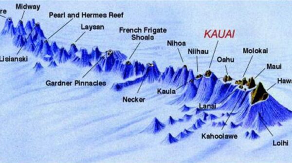

The Pacific Plate, one of Earth's massive tectonic plates, is slowly drifting northwestward at roughly the same rate your fingernails grow—just a few centimeters per year. While that may seem insignificant, this slow and steady movement over a stationary volcanic "hot spot" deep beneath the Earth’s crust has created one of the world’s most remarkable geological features: the Hawaiian Islands.
Over millions of years, this movement has generated a long chain of volcanic islands, forming one after another like an assembly line. This chain of islands, known globally as Hawai‘i, is the visible result of a deep, ongoing geological process that is still shaping the Pacific Ocean today.
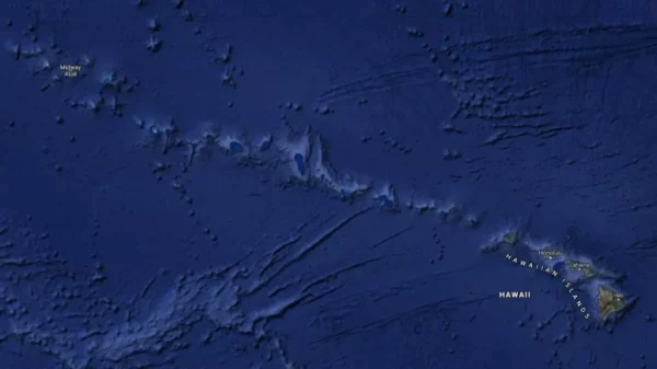
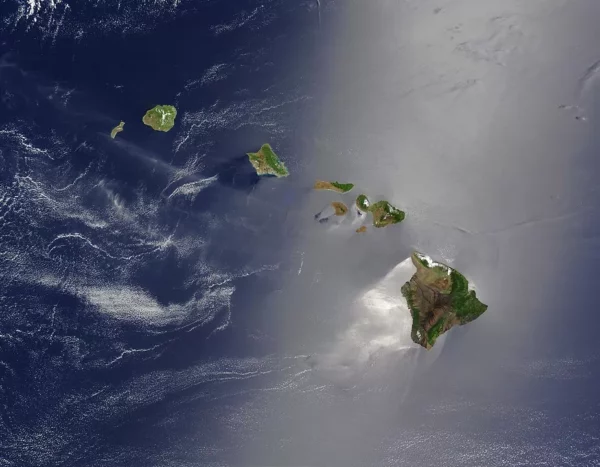
Situated near the center of the Pacific Plate, the Hawaiian archipelago stretches approximately 1,500 miles in a northwest direction from the southeastern tip of the Big Island toward Japan and the Aleutian Islands of Alaska. This impressive chain consists of eight major islands and 124 smaller islets, covering a total area of about 6,459 square miles.
The islands, from northwest to southeast, include:
Niʻihau
Kauaʻi
Oʻahu
Molokaʻi
Lānaʻi
Kahoʻolawe
Maui
Hawaiʻi (The Big Island)
Of these, the Big Island of Hawaiʻi is by far the largest, both in size and geological activity—and it's still growing.
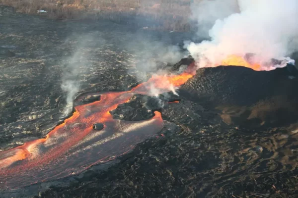
The island of Hawai‘i, the youngest in the chain, formed over one million years ago. Interestingly, it emerged not as a single volcano but as five separate submarine volcanoes: Kohala, Mauna Kea, Hualālai, Mauna Loa, and Kīlauea.
Over time, repeated eruptions built up layers of lava, which overlapped and eventually merged the five volcanic structures into one island. Today, only Kohala is considered completely extinct. The others remain active or dormant, still shaping the island’s landscape.
The formation of the islands followed a clear geological sequence. As the Pacific Plate moved, each volcano formed when it passed over the hot spot. Once it drifted away, volcanic activity ceased, and erosion and subsidence took over.
This volcanic process continues even now. About 18 miles off the southeast coast of the Big Island, an underwater volcano named Lōʻihi is actively erupting beneath the ocean's surface at a depth of 3,178 feet. In another 50,000 years or more, Lōʻihi could emerge as either a new island or become a sixth peak of the Big Island—depending on how it grows and merges.
The Big Island is home to five major volcanoes, each with its own characteristics and history:
The largest volcano on Earth by volume.
Covers about 51% of the island.
A shield volcano, with broad, gentle slopes formed by flowing lava.
Despite its size, it can be difficult to visually distinguish due to its low profile.
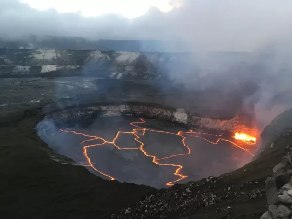
One of the most active volcanoes in the world.
Located on Mauna Loa’s eastern flank.
Once thought to be a vent of Mauna Loa, it is now known to have its own magma chamber.
Considered the sacred home of Pele, the Hawaiian goddess of fire.
Covers about 25% of the island.
Known for its snow-capped peak during winter (its name means “White Mountain”).
From base (on the ocean floor) to summit, it rises over 33,000 feet, making it the tallest mountain in the world when measured from base to peak—even taller than Mount Everest.
Located on the island’s western side near Kailua-Kona.
Less active, but still considered a potential threat, with its last eruption occurring in 1801.
The oldest and most eroded volcano on the island.
Extinct and heavily weathered, it features steep cliffs and lush valleys.
The dramatic Waipiʻo Valley, with its sea cliffs, likely formed from a massive landslide around 200,000 years ago.
Just across the ʻAlenuihāhā Channel, the island of Maui features Haleakalā, the world’s largest dormant volcano. Although it appears smaller than Mauna Loa or Mauna Kea, most of Haleakalā lies beneath the sea. Measured from its underwater base, it stands nearly 30,000 feet tall!
Haleakalā, which formed roughly 75% of Maui, last erupted in the late 1700s. Geologists believe that Maui was once part of a much larger landmass known as Maui Nui, which included the islands of Lānaʻi, Molokaʻi, and Kahoʻolawe. Over time, subsidence and rising sea levels caused the landmass to fragment into the separate islands we see today.
Geologists agree that Hawaii’s story is far from over. As the Pacific Plate continues to drift, the Big Island will eventually follow the path of Maui Nui—subsiding, eroding, and fragmenting into smaller landmasses. New islands will eventually rise to take its place as the hot spot remains stationary beneath the moving crust.
For now, however, the Big Island is still very much alive. With Mauna Loa and Kīlauea both actively erupting in recent years, the island is still growing, adding new land as lava flows reach the sea.
The Hawaiian Islands are not just a tropical paradise—they are a living, breathing geological phenomenon. Their landscapes tell a story written in molten rock, sculpted by time, and still unfolding beneath the waves of the Pacific Ocean.


By embracing a diet rich in leafy greens, garlic, berries, and heart-healthy fats, you not only prevent arterial damage but may also reverse early blockages.

From fighting bacteria and soothing inflamed gums to reducing sensitivity, healing ulcers, and combating bad breath, Tulsi provides a safe, holistic way to protect your smile.

This 100-year-old remedy is not just a drink—it’s a living tradition that has survived because it works.